洪水・高潮リスク情報埋め込み KeepDry
洪水・高潮リスク情報埋め込み KeepDry is a free Chrome add-on developed by 魚昆 月月鳥. This extension allows you to embed "Flood and High Tide Risk Maps" into real estate information websites.
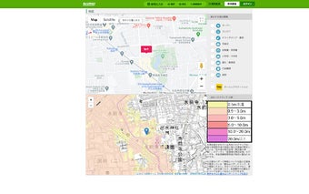
When considering real estate transactions or lease agreements, it is important to take into account the risk of water damage. With this extension, you can easily access the "Flood and High Tide Risk Maps" on the property's surrounding area map page of supported real estate information websites, currently limited to suumo.jp.
The Flood and High Tide Risk Maps are created by the Geospatial Information Authority of Japan and overlay data from the Ministry of Land, Infrastructure, Transport and Tourism's "Flood Inundation Expected Area (Maximum Expected Scale)" and "High Tide Inundation Expected Area." The developer of this extension has combined and displayed this data in a unique way. The extension also provides a link to hazard maps provided by the Ministry of Land, Infrastructure, Transport and Tourism, which includes not only flood and high tide risks but also tsunami, sediment disaster risks, and the locations of evacuation centers.
Please note that the "Flood and High Tide Risk Maps" displayed by this extension are not the water hazard maps created by municipalities based on the Water Disaster Prevention Law. When receiving important explanations from real estate agents, it is recommended to use the water hazard maps created by the municipalities.